Improving Biking and Walking in Monmouth
Monmouth’s Transportation System plan states as a goal:
Monmouth will develop and maintain a Transportation System Plan that encourages alternatives to, and reduces reliance upon the automobile.
The street designs in the TSP and actual implementation of the plan to date fall short of providing meaningful infrastructure to encourage people to use their cars less frequently. This causes many problems:
- It adds to the congestion on all roads in town.
- It increases the rate of wear on our streets.
- It pushes people of all economic means towards the most expensive way to travel (by several orders of magnitude).
- It denies people the opportunity to be physically active as a normal part of their day.
- It makes the city less livable for children, the elderly and the disabled who cannot drive, and also for those who should not drive but do not see a viable alternative and do so anyway.
- It increases Monmouth’s contributions to climate change.
To increase biking and walking in Monmouth, collectors and arterials must become inviting places for people to travel without the use of a car. These classes of street are designed for higher vehicle counts than local streets. Without inviting biking and walking facilities, people will be less inclined to leave their car at home for even short trips.
Suggested Improvements
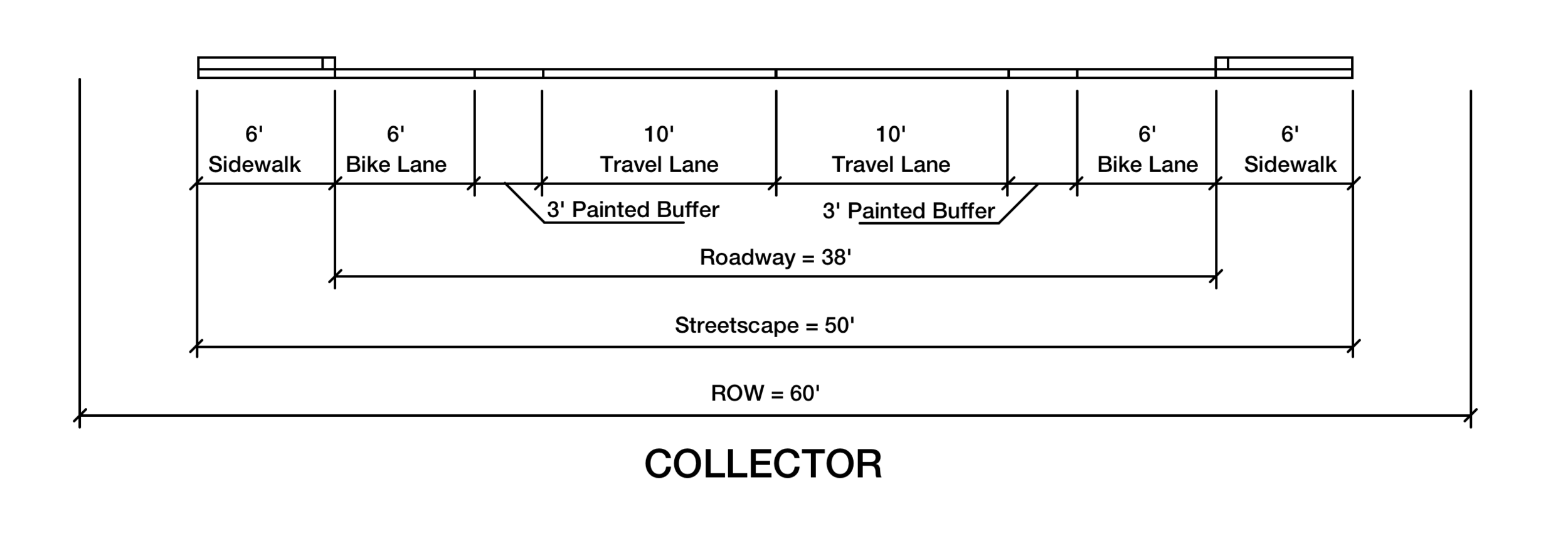
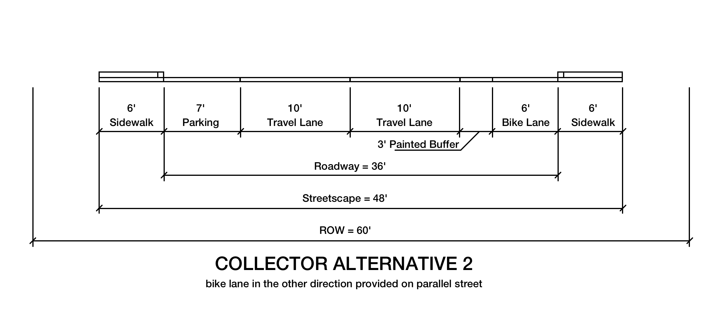
Update Monmouth’s Transportation System Plan to require protected bike lanes on all future connectors and arterials in town.
Update MCC 18.150.020 (21) to indicate that required bike lanes on arterials and connectors need to be protected bike lanes. Provide a definition for protected bike lanes.
Work to secure funding for completing sidewalks and adding protected bike lanes to all existing connectors and arterials in town, beginning with ODOT’s Highway 51 project.
- Adopt street construction and maintenance practices that recognize that speed limits are better controlled with street design rather than signage.
Better Biking
Monmouth has a lot going for it as a biking city. It’s compact and relatively flat. Winters aren’t as severe as other places, and rain, which we certainly get quite a lot of, tends to be intermittent. It is perfectly possible to bike around town today with no improvements at all.
But being merely possible is not enough to encourage the vast majority of people to take up biking as a viable form of transportation. Two things are necessary to increase ridership: visible indications that biking is an expected use of our streets, and a strong perception of safety when biking.
For connectors and arterials, bike lanes should be added in a way that is both highly visible and emphasizes perceived safety. This means providing adequate separation between bikes and vehicular traffic, and keeping bike lanes out of the “door zone” of parked cars.
For connectors, with their lower speed limits, minimal separation can be achieved with a painted buffer (as opposed to a single painted stripe). Better yet is to put the bike lane and buffer between the sidewalk curb and a row of parked cars.
For arterials, where parking is prohibited and speed limits are higher, a more substantial buffer will better encourage biking. Protected bike lanes are increasing in number throughout the country and bear study.
Another technique that can make bike lanes feel more substantial and make bikers feel more like they belong on the road is to use dyed pavement. Specifically, it is common in Europe to mix a red dye with the pavement used for bike lanes to make it clear what kind of vehicles they are for. This does not wear off in the same way that green paint will.
As a tangential topic, storm drains are an issue for bike lanes next to the curb. However, there are styles that sit completely in the curb rather than project out into the concrete pan and asphalt of the street.
Where to Start
Given that streets operate as a network, the biggest effects of improvement happen when the whole system is complete. However, given the finite nature of city finances and staffing, it is necessary to develop improvements in phases. There are several ways to prioritize:
- Highest-volume roads first
- Making improvement in conjunction with already-planned projects
- Areas with highest number of trip attractors
- Areas of highest population
It is important to keep in mind that one completed route is far more valuable than several incomplete routes. The upcoming highway 51 project is an opportunity to make significant progress on a major transportation corridor. After (or concurrently with) that project, I would suggest working from the center of the city outward. This would put priorities on:
- Madrona Street
- Clay Street
- Jackson Street
- Catron Street
- Craven Street
Funding sources
Oregon.gov has a page of possible funding sources and ideas from the local to state and federal programs. The Federal Highway Administration also has a spreadsheet listing which funds are good for which kinds of projects. Likely candidates to apply for funds include:
- State Transportation Improvement Plan
- State Highway Trust Fund
- Oregon Transportation and Growth Management Fund
- Federal: Transportation Alternatives Program
- Federal: Surface Transportation Program
- Federal: National Highway Performance Program
- Federal: TIGER Grants
A Few References:
Strong Towns - The Economic Benefits of Biking Cannot be Ignored
Reuters - Bike Lanes are a Sound Public Health Investment
CityLab - Protected Bike Lanes Aren't Just Safer, They Can Also Increase Cycling
National Association of City Transportation Officials
Jeff Speck - Walkable City: How Downtown Can Save America, One Step at a Time
ODOT Bicycle and Pedestrian Guide (PDF)
Some Suggested TSP Revisions


